For nearly one hundred years Kohukohu was an important timber milling town and the largest commercial centre on the north of the harbour. In 1900, the township had a population of almost 2,000 people
About 1819 Messrs Raine, Ramsay, and Browne, a Sydney firm, established a sawmill and shipyard. In a comparatively short time this became a thriving settlement and by the 1830s was popularly known as “the Deptford of the South”. Meanwhile traders in flax, squared timber, and spars were slowly appearing on the scene and setting up shore bases. Of these newcomers the most well known were G. F. Russell, F. E. Maning, whose home still stands at Onoke Point, and Thomas McDonnell, who had a shipyard at Horeke. Clendon, later American consul at the Bay of Islands, was another early settler. Baron de Thierry, the self-styled “King of New Zealand”, settled in 1837 at Mount Isabel (called after his daughter), near Rangiahua. In February 1840 Captain Hobson addressed a large gathering of Maoris at the mission when he induced a number of chiefs to add their signatures to the Treaty of Waitangi.
Hokianga's prosperity was built on kauri timber and kauri gum. Mills were established in the 1870s and milling operations were conducted at Kohukohu, Rangiora, Koutu, Waima, Rawene, Horeke, and Waimamaku. The chief gum areas were near Taheke, at Koutu, and around Rangi Point. Today the mainstay of the area is farming, though some building sand and agricultural limestone are produced.
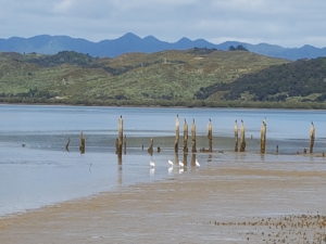
Constructed in 1879 the wharf was originally reported to be 450ft (137m) in length and 30ft (9m) in width. The piles are all squared totara and the rest of the timber used in its construction (now gone) was heart of kauri. In its day vessels drawing up to 20ft (6m) of water could load at the wharf during high tide. A photograph dated 1913 shows the wharf was ‘T’ shaped and had a large timber wharf building near the landward/ western end. Today the wooden piles (with top ends cut for the bearers of the wharf runners and decking) are sticking out of the mudflats. The former alignment of the wharf, running east into the Hokianga Harbour, is evident and it is possible the wharf extended further landward (now under Kohukohu road) to the west. The piles and area of reclamation are the only visible remains of the late 19th to early 20th century timber mill.
Considerable more information can be found about these wharf pile here.